


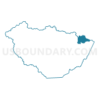
Voting District 11, McDowell County, West Virginia
About
Outline

Summary
| Unique Area Identifier | 691158 |
| Name | Voting District 11 |
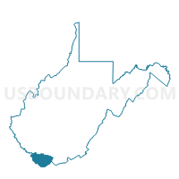
| County | McDowell County |
| State | West Virginia |
| Area (square miles) | 10.51 |
| Land Area (square miles) | 10.50 |
| Water Area (square miles) | 0.01 |
| % of Land Area | 99.88 |
| % of Water Area | 0.12 |
| Latitude of the Internal Point | 37.43885040 |
| Longtitude of the Internal Point | -81.39096540 |
Maps

Graphs
Select a template below for downloading or customizing gragh for Voting District 11, McDowell County, West Virginia


Neighbors
Neighoring Voting District (by Name) Neighboring Voting District on the Map
- Voting District 10, Wyoming County, WV
- Voting District 14, McDowell County, WV
- Voting District 15, Wyoming County, WV
- Voting District 40, McDowell County, WV
- Voting District 50, McDowell County, WV
- Voting District 6, McDowell County, WV
Top 10 Neighboring County Subdivision (by Population) Neighboring County Subdivision on the Map
- District 1, Wyoming County, WV (7,419)
- Browns Creek district, McDowell County, WV (5,362)
- North Elkin district, McDowell County, WV (4,817)
Top 10 Neighboring Place (by Population) Neighboring Place on the Map
Top 10 Neighboring Unified School District (by Population) Neighboring Unified School District on the Map
Top 10 Neighboring State Legislative District Lower Chamber (by Population) Neighboring State Legislative District Lower Chamber on the Map
Top 10 Neighboring State Legislative District Upper Chamber (by Population) Neighboring State Legislative District Upper Chamber on the Map
Top 10 Neighboring 111th Congressional District (by Population) Neighboring 111th Congressional District on the Map
Top 10 Neighboring Census Tract (by Population) Neighboring Census Tract on the Map
- Census Tract 32, Wyoming County, WV (4,911)
- Census Tract 9545.03, McDowell County, WV (3,827)
- Census Tract 9545.01, McDowell County, WV (2,121)
- Census Tract 9536, McDowell County, WV (1,487)